Updated: Snow, bitter cold - Bring pets inside, watch the pipes don’t freeze
UPDATE — The forecast has changed as of 11 p.m, Friday night, and the Midcoast is going to get even more snow. A winter storm warning is now in place until midnight, Saturday night, Feb. 13, and a windchill advisory remains in effect from then until 10 a.m. Sunday.
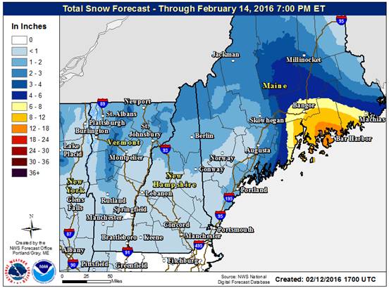
Meteorologists are now predicting heavy snow, from 6 to 10 inches, with even higher accumulations in certain narrow bands.
Wind chills are anticipated to fall to 27 below zero Fahrenheit, with northwest gusts up to 35 miles per hour.
Depending on the track of a trough, the Midcoast may get a good amount of localized snow on Saturday. With it, bitterly cold air and a strong northwest wind is to compound the winter conditions.Meteorologists are watching the likelihood that a deepening trough (low atmospheric pressure) between two air masses will bring snowfall to the Maine coast. Where the heaviest snow falls depends on its path. As of Friday evening, the trough could settle on the Midcoast, or head Downeast toward the Mount Desert area. If it’s the latter, the Midcoast and Penobscot Bay area won’t see so much snow; however, MDI could see up to 15 inches of it.
In any case, the cold behind it will shiver the bones. Take care of pets, and bring them inside. Make sure water for livestock and horses is not frozen. And, beware the potential for freezing water pipes, which quickly can lead to burst water pipes.
And, check on your neighbors, especially the elderly.
As of Friday evening, the National Weather Service in Gray was calling for a winter storm watch for Saturday and a wind chill advisory for Sunday. The western mountains are to be even colder, where wind chill temperatures there are forecast to be minus 30 to minus 70 F, depending where on a hill one might be.
The NWS is expecting the following:
Reach Editorial Director Lynda Clancy at lyndaclancy@penbaypilot.com; 207-706-6657