Rockland-Rockport Route 1 strip redesign due back before city council
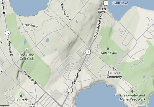
ROCKLAND — Work began in 2011 to envision what Camden Street (Route 1) from Rockland to Glen Cove in Rockport might look like with improvements. Committees and officials from Rockland and Rockport gathered many times to discussion designs and enhancements. They walked the strip and brainstormed around tables. Later, landscape architects and engineers were hired to produce concepts. The “Unlocking the Potential” project even went before the Rockland City Council by November 2013, as assorted designs were unveiled.
Then, there was pause in the public discussion as engineers from Gorrill-Palmer Consulting Engineers, of Gray, took the drawings back to their tables for even more work. Now the project is due to reemerge before the council sometime in March, according to City Manager James Chaousis.
“There’s been a lot of work with traffic data collection,” he said, in a Jan. 25 phone conversation.
Chaousis reported in his weekly manager’s report that, “the project team met with Gorrill-Plamer regarding the Camden Street design. It was a very promising meeting. We have given further direction to the engineer and will deliver a report to the City Council in March. This coincides perfectly with the budget process. It is my hope and desire to make the Camden Street improvement, on some level, in the 2017 construction year.”
The city’s project team, according to Chaousis, consists of Public Services Director David St. Laurent and Finance Director Virginia Lindsey, as well as himself.
Gorrill-Palmer has preliminary designs to present, Chaousis said.
He said the council would then possibly consider reconvening the Rockland Economic Development Advisory Committee to review progress. He also said that the town of Rockport is a vital part of the discussion.
The effort to make the 1.5-mile stretch of Route 1 between Rockland and Rockport, now a mix of old homes and big box stores, asphalt, traffic and sidewalks a better place to live, shop and travel along began when Jane Lafleur, executive director of the nonprofit Friends of Midcoast Maine, helped to secure $70,000 in grant money from several private foundations to help REDAC and the city define alternative landscapes.
She said, in August 2013: “This can be a 10 or 20-year plan. It’s important that people understand that. We are presenting concepts and it is up to the city to take them further.”
But, she said, the draft concepts "show that we can unlock the potential of that neighborhood," she said.
In September 2012, a group of citizens gathered at the Breakwater to help develop a community visionfor the strip that runs along the northern end of Rockland Harbor toward the Rockport town line. The goal then was to assess their city and this particular section. Friends of Midcoast Maine facilitated that meeting, and subsequent gatherings, moving through a process that included a walking tour of the strip to the intersection of Route 17 (Maverick and Waldo streets).
Citizens collectively agreed they wanted a landscape that reflects the heritage and history of Rockland, "a place that they can be proud of," said Lafleur. And, she said, they wanted a walkable environment, one that promotes pedestrian and bicycle traffic, not just vehicular traffic.
Lafleur held seven design workshops with the city’s REDAC.
Click here for the design principles.
Click here for design summaries.
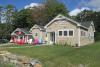
The strip of highway alternatively referred to as Route 1 and Camden Street, extends from the Glen Cove neighborhood of Rockport to the Route 17 intersection, near Burger King and McDonald's. Once farmland, it has over the last 40 years become predominantly commercial. In the summer, it can be slow-going through the area, as tourists make their way to Rockland, and shoppers enter and exit Home Depot, Walmart, and a shopping plaza home to Shaw's, Staples and T.J. Maxx, among others. Still, it has a neighborhood feel to parts of it, as residential homes and sidewalks run alongside it.
In 2013, an economic analysis of tax revenue of downtown versus the commercial strip was conducted. Additionally, landscape architects and planners Terrence J. DeWan and Associates, with partners HNTB and C. Michael Lewis, were hired to produce conceptual designs. Part of the process included inviting property owners in Rockland and Rockport to submit their properties for redesigns.
An anonymous donor from Rockland has also donated $10,000 to the effort, asking that each Rockland site have two designs produced.
Related stories
Defining a city, one adjective at a time
Unlocking potential of the Route 1 Rockland-Rockport strip
http://www.penbaypilot.com/article/unlocking-potential-rockland-rockport...
Reach Editorial Director Lynda Clancy at lyndaclancy@penbaypilot.com/207-706-6657